


- 02:19 h
- 293 m
- 294 m
- 1,596 m
- 1,888 m
- 292 m
- 7.26 km
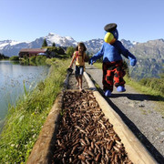
- Start: Ristis
- Destination: Ristis
The panoramic round walk starts at the Ristis summit terminus of the Brunni cableway. This can easily be reached from Engelberg railway station using the free summer bus and the Brunni aerial cableway. The 7 km well-established educational nature trail turns right at Ristis towards Rigidalalp and on to the Brunnihütte refuge. This part of the trail has interpretation panels as well as clues for "Globi's Treasure Hunt". This family-oriented game involves using a special treasure map: help Globi find the treasure and you'll be rewarded at the end of the walk. Information and the treasure map may be obtained from the Ristis terminus. Walkers not participating in the game will probably be observing the flowery alp meadows. More than 100 plant species are described on the panels along the panoramic path.
On arrival at the Brunnihütte refuge, you're met with splendid views of the Titlis and Hahnen, while Lake Härzli - which is encircled by a Kneipp foot hydrotherapy "tickle path" - is perfect for cooling tired feet, so shoes off! You'll find the next section of the round walk easier on the feet. You might like to eat something at the refuge: the menu alone is enough to make your mouth water, what with its traditional Swiss specialities such as rösti and alp cheese and homemade fruit tarts. Go on, you've earned a break!
Thus fortified, it's time to turn back. The path remains on the same level as far as Rosenbold. Once at this vantage point, take a few snaps while you consult the panel describing the peaks on the skyline: you don't see a panorama like this every day. From now on it's downhill all the way back to Ristis. Take the cableway and bus back to the village.
Note: you can also walk between Engelberg and Ristis.
Waypoints
Good to know
Best to visit
Directions
Tour information
Loop Road
Stop at an Inn
Directions & Parking facilities
Author
Engelberg - Titlis Tourismus
Organization


