


- 05:45 h
- 14.83 km
- 2,042 m
- 759 m
- 511 m
- 2,182 m
- 1,671 m
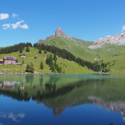
- Start: Brändlen, mountain hut
Have you always wanted to go on a multi-day hike? If so, we recommend the Buiräbähnli Safari. This challenging hike takes roughly 20 hours and includes two overnight stops. The circular trail starts and finishes at Engelberg railway station.
The following morning the hike continues via Gigi to Haldigrat, then back down along the zigzag trail to Haghütte and onwards up to Bannalp. Here you join the Walen Trail as far as Alp Oberfeld, the location of your second overnight stay on the hike.
See also
Engelberg-Titlis Tourismus AG
Klosterstrasse 3
Postfach 149
CH-6391 Engelberg
E-Mail: welcome@engelberg.ch
Internet: www.engelberg.ch
Good to know
Best to visit
Directions
Berghof Brändlen - Gigi - Haldigrad - Rinderbalm - Haghütte - Chrüzhütte - Oberfeld
Tour information
Stop at an Inn
Author
Engelberg - Titlis Tourismus
Organization
Region Luzern-Vierwaldstättersee
Author´s Tip / Recommendation of the author
In the Brändeln there is the possibility to stay overnight and to eat there - but only on reservation. One night costs CHF 40.00
Nearby


