- 2:15 h
- 6.98 km
- 253 m
- 260 m
- 435 m
- 657 m
- 222 m
This scenic themed hiking trail provides information about the sweet chestnut tree at the foot of the Rigi. Chestnuts once played an important role in our diet. You can still see the remains of chestnut groves and sweet chestnuts today.

Good to know
Pavements
Street
Trail
Best to visit
suitable
Depends on weather
Directions
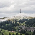
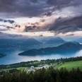
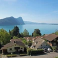
Leaving Vitznau, the path continues southwards along the Gotthardstrasse towards Gersau and the County of Schwyz. En route enjoy the wonderful views of the bay of Lucerne. From the “Milch Bänkli” continue through the woods and meadows to Unterlinden. From here the route becomes more challenging, passing an area rich in flora to “Menschenacher” 750 m a.s.I. This superb lookout point has a panoramic view comprising of the Klewenalp, the Stanserhorn, the Bürgenstock and the Pilatus, as well as the bays of Lucerne, Horw, Gersau and Buochs. The last part of the walk passes through meadows and woods before descending into the historic Republic of Gersau. Here you can either take the bus or boat back to your starting point.
Directions & Parking facilities
From the motorway exit Küssnacht follow the main road to Vitznau
Parking in the centre of Vitznau
- By boat from Lucerne to Vitznau
- By train and bus from Lucerne via Küssnacht to Vitznau
- By bus and boat from Gersau
Author
Tourist Information Weggis (Luzern Tourismus AG)
Organization
Tourist Information Weggis
Nearby