


- 2:15 h
- 6.67 km
- 404 m
- 399 m
- 435 m
- 779 m
- 344 m
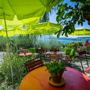
Ce sentier de randonnée thématique offrant une belle vue informe sur la présence de la châtaigne au pied du Rigi. Les châtaignes jouaient autrefois un rôle important dans l'alimentation. Et aujourd'hui encore, on peut repérer les reliques de châtaigneraies et de châtaigniers.

Good to know
Best to visit
suitable
Depends on weather
Directions
The path between Vitznau and Weggis starts with a slight ascent and continues partly through the Chilewald woods. At Bannholz turn right, here the trail becomes more challenging. Continue walking for about 300 metres until you reach the nature reserve Chesteneweid. Here there is anabundance of wildlife and flora usually only found on the southern side of the Alps. Before hiking upwards to the Orenpfad you can decide whether to end the walk here and walk down to the bus stop at Lützelau, or continue upwards to the highest point of the walk, Wilen, 774 m a.s.I. This stage of the walk has a difference in altitude of 130 m, over a relatively short distance and is made up of a number of steps and ladders, therefore good footwear is essential. Your efforts are rewarded by a fantastic view of the central part of Lake Lucerne and the village of Vitznau below. The steep but short hiking trail brings you to the Oberwil farm, from here follow the small panoramic road back to the centre of Vitznau.
Tour information
Nature Highlight
Directions & Parking facilities
From the motorway exit Küssnacht follow the main street to Weggis
Parking in the centre of Weggis
- By boat from Lucerne to Weggis
- With train and bus from Lucerne via Küssnacht to Weggis
- Bus and boat from Vitznau
Author
Tourist Information Weggis (Luzern Tourismus AG)
Organization
Tourist Information Weggis
Nearby


