How would you like to arrive?
- 5:00 h
- 37.76 km
- 1,590 m
- 1,590 m
- 432 m
- 1,657 m
- 1,225 m
- Start: Brunnen - landing stage
- Destination: Lucerne
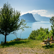
A wonderful panorama of the nearby peaks accompanies you along the entire route today. From the shores of Lake Lucerne in Brunnen, you float up to the Urmiberg by cable car. This is followed by a challenging hike over the Gätterli pass, past the Berggasthaus Burggeist mountain inn. Lots of photo opportunities, including at the Känzeli vantage point. The views of fjord-like Lake Lucerne are overwhelming. Shortly afterwards you reach Rigi Kaltbad. Take the cog railway down to Vitznau and the boat to Lucerne.
Walking time: approx. 5 hours | Distance: 16 km (not including cableway, railway and boat) | Total elevation gain: 843 m ( including cableway, etc.: 1,537 m) | Total elevation loss: 430 m (including cableway, etc.: 1,537 m)
Waypoints
Good to know
Best to visit
Directions
Tour information
Mountain Railway Tour
Stop at an Inn
Equipment
Directions & Parking facilities
Additional information
Further information on the Tell Trail: www.luzern.com/telltrail
Author
Laila Bosco
Organization
Region Luzern-Vierwaldstättersee
Safety guidelines
• Good surefootedness
• Average navigation skills
• Elementary alpine experience
Nearby


![[Translate to Englisch:] Gästekarte Luzern Gästekarte Luzern](https://www.luzern.com/fileadmin/_processed_/6/4/csm_SGV_2017_aa603a6780.jpg)


