


- 6:30 h
- 22.35 km
- 820 m
- 819 m
- 434 m
- 886 m
- 452 m
- Start: Luzern, boat station
- Destination: Alpnachstad
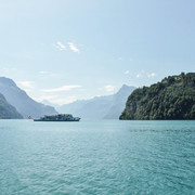
Crowning stage over the Renggpass - Past the KKL and Tribschen estate via the Horwer peninsula at the foot of Mount Pilatus. Passage over the Renggpass, the only overland link to Obwalden in the 1860s before the construction of the Brunigstrasse.
Note(s)
Route number 98 is always signposted. As regional route of the SwitzerlandMobility network, it is signposted throughout and in both directions.
See also
Luzern Tourismus AG
Tourist Information
Zentralstrasse 5
CH-6002 Luzern
Tel.: +41 (0)41 227 17 17
E-Mail: luzern@luzern.com
Internet: www.luzern.com
Verein Weg der Schweiz & Waldstätterweg
Geschäftsstelle Brunnen Tourismus
Bahnhofstrasse 15
CH-6440 Brunnen
Tel.: +41 (0)41 825 00 40
E-Mail: info@waldstaetterweg.ch
Infos zum Waldstätterweg: www.waldstaetterweg.ch

Good to know
Best to visit
Directions
Additional information
Luzern Tourismus AG
Tourist Information
Zentralstrasse 5
CH-6002 Luzern
Tel.: +41 (0)41 227 17 17
E-Mail:
Internet: www.luzern.com
Verein Weg der Schweiz & Waldstätterweg
Geschäftsstelle Brunnen Tourismus
Bahnhofstrasse 15
CH-6440 Brunnen
Tel.: +41 (0)41 825 00 40
E-Mail:
Infos zum Waldstätterweg: www.waldstaetterweg.ch
Author
Carla Hendry
Organization
Region Luzern-Vierwaldstättersee
Nearby


