


- 2:57 h
- 11.24 km
- 115 m
- 115 m
- 782 m
- 858 m
- 76 m
- Start: Hämikon, Berg
- Destination: Hämikon, Berg
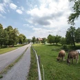
The walk starts at the Gasthaus Hämikerberg, an inn which is easily accessible by car or public transport. You walk through Müswangen over the Matten to the Sulzer Kreuz. The path takes you along the edge of the forest via Oberillau to the Horben alp with its good food and great views. You continue through the Sulzer forest back to the Sulzer Kreuz and the Hämikerberg inn, where you can relax over a refreshing drink.
Tip: the inn (alt. 810 m) has a webcam so you can check in the winter months whether the walk is above the fog/clouds before you set off. www.horben.ch
Good to know
Pavements
Best to visit
Directions
Tour information
Loop Road
Directions & Parking facilities
Additional information
Horben alp: www.horben.ch (closed Tuesdays)
Author
Seetal Tourismus
Organization
Seetal Tourismus
Author´s Tip / Recommendation of the author
- Gasthaus Hämikerberg: www.gasthaus-haemikerberg.ch (Montag geschlossen)
- Spiel!Golf Hämikerberg: www.spielgolf-schweiz.ch
- Alpwirtschaft Horben: www.horben.ch (Dienstag geschlossen)
- Sulzer Kreuz
Map
Landeskarte 1:25'000 (Bundesamt für Landestopografie swisstopo) Blatt Hochdorf
Wanderkarte 1:50'000 (Bundesamt für Landestopografie swisstopo) Blatt Rotkreuz
Nearby