


- 4:45 h
- 14.51 km
- 573 m
- 568 m
- 434 m
- 695 m
- 261 m
- Start: Brunnen, ferry terminal
- Destination: Vitznau
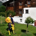
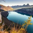
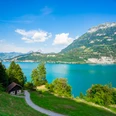
From Brunnen via the Waldstätterquai and Auslandschweizerplatz to Seestrasse up to Brünischart. Here begins the mountain hiking trail through the southern-like forest vegetation with a magnificent panoramic view. Via Gersau, you then reach Vitznau.
The Waldstätterweg is continuously marked as a regional route of the SchweizMobil network and signposted in both directions as Route No. 98.

Good to know
Best to visit
suitable
Depends on weather
Directions
Brunnen - Gersau - Vitznau
Additional information
Association Weg der Schweiz & Waldstätterweg
Brunnen Tourism Office
Bahnhofstrasse 15
CH-6440 Brunnen
Tel.: +41 (0)41 825 00 40
E-Mail:
Brunnen Tourism Office
Bahnhofstrasse 15
CH-6440 Brunnen
Tel.: +41 (0)41 825 00 40
E-Mail:
Organization
Schwyzer Wanderwege
Safety guidelines
Due to rockfall, the hiking trail between Fallenbach and Brünischart is closed until further notice. As an alternative, use the sidewalk along the cantonal road.
Nearby


